
Britain’s edges are on the move. The tide rises, cliffs slump, and whole streets vanish without ceremony. Five villages once mapped and loved now survive as stories, ruin lines and ripples on a sonar screen. The sea didn’t ask permission.
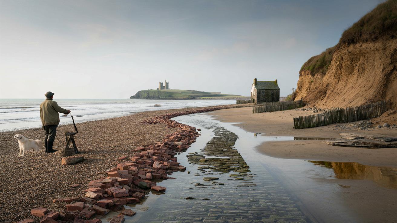
The North Sea is doing what it does: leaning in, stealing inches, then metres. A fisherman points to a line of darker water offshore, as if he’s naming a road. “That was Dunwich High Street,” he says, then looks back to his dog, who’s impatient for the next throw. The shingle rasps like a whisper you can’t quite catch.
Some places feel louder in their absence. We’ve all had that moment when the ground under a memory shifts. The light thickens, a bell you can’t hear feels like it’s ringing. The map is lying.
Five villages the sea took — and the traces that remain
The British coast doesn’t just edge the land. It edits it. On some stretches, the sea has swallowed entire places: Dunwich in Suffolk, once a thriving port; Hallsands in Devon, ripped open in a single night; the sand-built port of Ravenser Odd on the Humber; Reculver in Kent, where a Roman fort and medieval village slid away; and Old Winchelsea in East Sussex, unmade by storms. Walk these shores and you catch odd clues — brick shards under kelp, a rotting timber that used to be someone’s lintel, a boundary bank ending mid-air. **Britain’s Atlantis** isn’t a myth. It’s a postcode you can’t post to.
Hallsands is the story that lodges under the skin. Late January 1917, a screaming easterly and a high tide tear at walls already weakened by shingle dredging down the coast. By dawn, most of the village has gone. Eyewitnesses talked of floors lifting like trapdoors. Families flee uphill with what they can carry; only one house clings on, stubborn as a gull. A generation earlier, there were 37 homes here and a busy fishing life. Today, you stand on a viewing platform, and the sea just breathes, as if nothing happened. That calm feels indecent.
Why do we lose places like this? Part geology, part weather, part human nudge. The Holderness coast, feeder for Ravenser Odd, is made of soft boulder clay that melts like chocolate in the sun; longshore drift scrapes away the base, and whole cliffs slump. Medieval storms in 1287 rearranged the south-east, exporting Old Winchelsea into the channel. The **Grote Mandrenke** of 1362 drowned Ravenser Odd and reset the mouth of the Humber. At Reculver, Roman walls once sat safely inland; centuries of bite and nibble pushed the sea underneath them until only the twin towers stand tall. Add rising seas and fiercer storms and the script writes itself.
How to see what’s gone — safely, and with care
Start with timing and lines. Pick a low-tide window and map your viewpoint, not the vanished streets. For Dunwich, the stand-out angle is from the shingle facing Greyfriars Priory, when the light rakes across the water. Hallsands works from the signed platform near Beesands, a respectful distance from the fragility below. Reculver’s twin towers are a perfect marker for sea’s bite; walk the sea wall, then step back to catch the horizon. Use OS Maps or a local tide app, and give yourself an hour either side. Binoculars change everything.
There’s a right kind of curiosity, and a wrong one. Don’t lean out over raw edges or step onto undercut cliff tops, no matter how photogenic the view. Clay breaks in silence, and it breaks fast. Dogs on leads around crumbling ground and nesting birds. Drones are often banned on nature reserves like Spurn; wind and wires don’t care for your reel. Park considerately in small villages. Talk to people — the best detail often comes from a postmistress or a beachcomber. Let’s be honest: nobody really does that every day. But the morning you do, the place opens up.
Look for emotion as much as artefact. At Kilnsea, facing the ghost of Ravenser Odd, the sea is flat and the story is vertical, falling away beneath the waves.
“The coast keeps receipts,” a warden told me. “It just files them somewhere you can’t reach unless you listen.”
- Dunwich, Suffolk: scan from the beach by the priory ruins; the museum road panel has the old street grid.
- Hallsands, Devon: use the clifftop platform; the ruined walls below are private and unstable.
- Reculver, Kent: stand by the towers and trace the edge where the Roman fort once ran inland.
- Ravenser Odd, off Spurn: best sensed from Kilnsea; any “landfall” is tidal and treacherous.
- Old Winchelsea: head to Winchelsea Beach and imagine the town where the waves now shoulder in.
The coastline doesn’t forget
Spend a day with these absences and something shifts in how you read a map. Lines that look fixed start to feel like a pause. You notice the quiet industry of the sea, moving sand grain by grain, year after year, like someone erasing a pencil mark and blowing away the dust. History gets less tidy. Town charters, ports that rivalled kings, farms that paid tithes — all reduced to a colour change on the water and a few coins dredged by a winter storm. The story isn’t just sorrow. It’s also adaptation, and a kind of everyday courage. People make new harbours, new streets, new habits. The past isn’t gone. It just keeps changing postcodes.
| Key point | Detail | Interest for the reader |
|---|---|---|
| Five UK villages disappeared into the sea | Dunwich, Hallsands, Ravenser Odd, Reculver village, Old Winchelsea | Names to search, places to visit, stories to tell |
| Why they vanished | Soft geology, storm clusters in 1287 and 1362, dredging, longshore drift, rising seas | Clear, relatable science behind the drama |
| How to witness them safely | Low-tide viewpoints, mapped paths, local advice, stay behind fences, **check the tide tables** | A practical plan for a meaningful, risk-aware day out |
FAQ :
- Can you really see Dunwich under the water?Not in a neat, film-style way. On calm days with low sun you’ll spot darker patches and the line of the old harbour mouth. The Dunwich Museum has maps that help your eye, and divers have filmed rubble and timbers offshore.
- Is Hallsands open to explore?You can view it from the official clifftop platform. The ruined houses below are dangerous and on private land. Erosion continues, and access changes after heavy weather. Choose a still day and let the site speak from a distance.
- What was Ravenser Odd, and where is it now?A medieval port on shifting sands near today’s Spurn Point. It rivalled Hull for trade before storms and the sea erased it in the 14th century. Stand at Kilnsea and you’re looking towards its former streets, now seabed.
- Why is the Holderness coast vanishing so fast?It’s mostly soft boulder clay from the last ice age. Waves undercut the base, longshore drift carries the debris south, and the cliff face slumps. Average retreat is measured in metres per year along some stretches.
- When’s the best time to visit these sites?Low tide, an hour either side, on a calm day with clear light. Dawn and late afternoon add texture and mood. Local tide apps and harbour boards are your friends; sunrise after a storm can be unforgettable.


Haunting and beautifully written—’the coast keeps receipts’ will stick with me. I visited Reculver last year and your safety notes are spot-on; those clay edges look solid until they’re not. Could you link the OS map layers you used? I’d definately love to compare with old charts. Also curious about the Dunwich museum panel you mention—any photo of that grid? Thanks for balancing romance with caution; too many pieces like this forget dogs on leads and tides that dont care.